"Lone Star Historian" is a blog about the travels and activities of the State Historian of Texas. Bill O'Neal was appointed to a two-year term by Gov. Rick Perry on August 22, 2012, at an impressive ceremony in the State Capitol. Bill is headquartered at Panola College (www.panola.edu) in Carthage, where he has taught since 1970. For more than 20 years Bill conducted the state's first Traveling Texas History class, a three-hour credit course which featured a 2,100-mile itinerary. In 2000 he was awarded a Piper Professorship, and in 2012 he received the Lifetime Achievement Award from the Wild West Historical Association. Bill has published almost 40 books, half about Texas history subjects, and in 2007 he was named Best Living Non-Fiction Writer by True West Magazine.
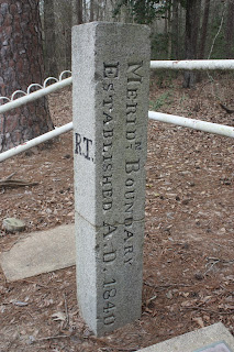
The only original boundary marker in the contiguous United States stands in southeastern Panola County. On June 1, 1840, the steamboat Albert Gallatin stopped its northbound journey up the Sabine River at Logan's Ferry (later Logansport). Passengers included a commissioner and a surveyor from the United States, and a commissioner and a surveyor from the Republic of Texas. These men were setting the border between the United States and the Republic of Texas from the Gulf of Mexico to the Red River. The southern part of the boundary was the Sabine River, but just above Logan's Ferry the river turned toward the northwest. At this turning point a meridian line was surveyed northward to the Red River, and a granite marker was placed on the north-south meridian. One side of the marker has the letters "R.T.," while another side announced, "Meridn [sic] Boundary Established AD 1840." (A larger marker - ten feet tall - at the nearby Sabine River has been lost to erosion.) This unique historical artifact may be found in a small park on the north side of Highway 31 below the rural community of Galloway.
 Pulaski, the seat of Panola District, was about 12 miles to the northeast of the boundary marker, perched on a bluff overlooking the east bank of the Sabine River. A river ferry just to the north gave birth to the log cabin village. The log structures of Pulaski were arranged in a rough triangle, and included a one-room log courthouse. When Harrison County was organized in 1839, Pulaski served as the seat of government until 1841, when Marshall was founded as county seat. Panola District became Panola County in 1846, and Pulaski was the first county seat, until Carthage was founded near the center of the county in 1848. No trace of Pulaski remains today, except the roadway and ferry site. The deserted townsite is on private property and is difficult to reach.
 Pulaski, the seat of Panola District, was about 12 miles to the northeast of the boundary marker, perched on a bluff overlooking the east bank of the Sabine River. A river ferry just to the north gave birth to the log cabin village. The log structures of Pulaski were arranged in a rough triangle, and included a one-room log courthouse. When Harrison County was organized in 1839, Pulaski served as the seat of government until 1841, when Marshall was founded as county seat. Panola District became Panola County in 1846, and Pulaski was the first county seat, until Carthage was founded near the center of the county in 1848. No trace of Pulaski remains today, except the roadway and ferry site. The deserted townsite is on private property and is difficult to reach.
 |
| Looking north at the Sabine River from the bluff occupied by Pulaski. A wagon road at right went down to the east bank and a ferry. |
 |
| Watt Moorman was buried in this private cemetery atop a hill near his family home, which was downhill to the right. Bounded today by four posts, the little cemetery has ten unmarked graves. |


No comments:
Post a Comment